Our partner company ESS Weathertech has released a comprehensive series of articles on satellite ground stations. We would like to share them with ESS Earth Sciences’ readers. A big thank you to Amy Hewitson from ESS Weathertech who is the author of the articles.
What are satellite ground stations?
Satellite Ground Stations (SGS) are built for collecting and streaming remote sensing satellite data to a variety of users and applications. This may include national weather centres such as the Bureau of Meteorology or research centres like CSIRO. Such centres collect weather and other data to provide customers and the public.
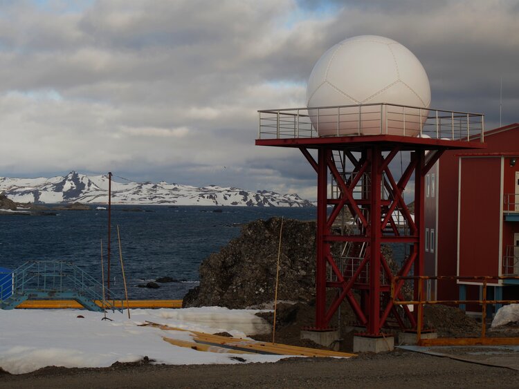
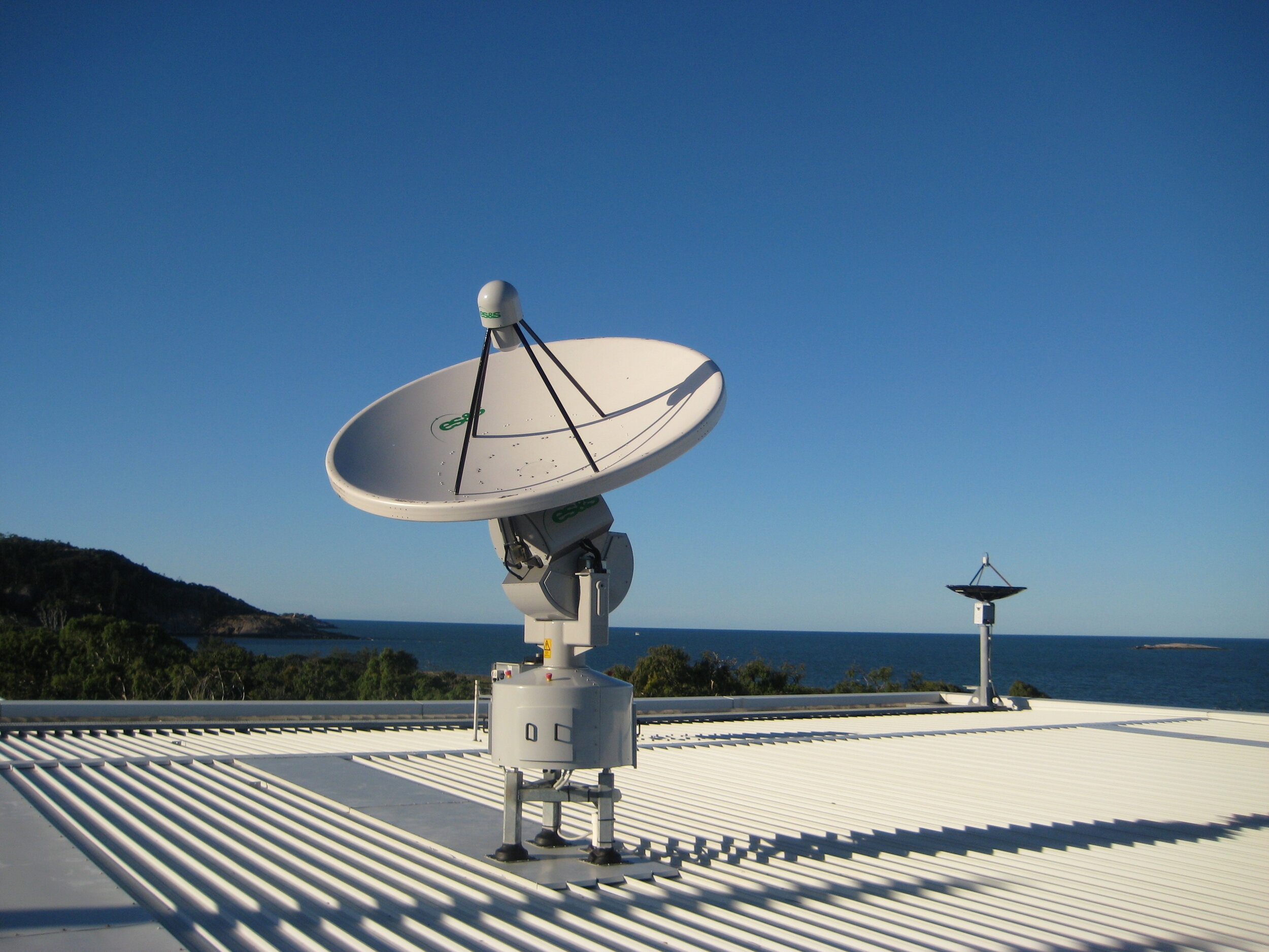
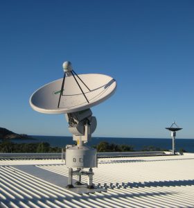
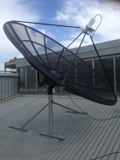
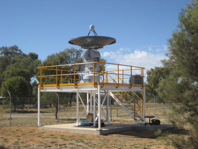
Satellite ground stations generally consist of the following main components: a reception antenna, a feed horn, waveguide, and receiver. All typically mounted on a pedestal. Satellite Ground Stations can also be protected by a ‘radome’; the sphere used to cover the antenna.


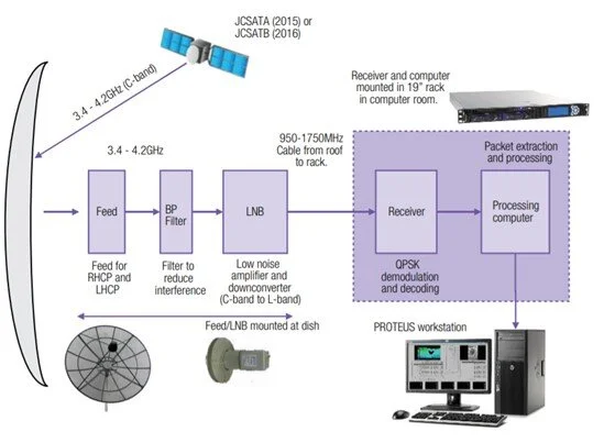
The antenna is the eye-catching, parabolic dish. The dish shape is designed to accurately direct and reflect incoming radio waves. However, the main purpose of the antenna is to amplify the incoming signal without adding significant noise. The smaller antenna located at the focal point of the parabolic antenna is called the feed horn. The feed horn is used to gather the reflected signals from the dish and is transferred to a Low Noise Block (LNB). The LNB converts the signal for further processing. Such as demodulation where the original source signal is extracted from the received carrier wave, and eventually is visualised on a computer or television, etc.
Electromagnetic waves
The electromagnetic waves travelling from distant satellites are only a few trillionths of a watt by the time they reach the parabolic antenna. The dish amplifies these tiny signals thousands of times, without distortion or noise, and focuses them on the feed at the centre. Here, the electromagnetic waves are converted into electrical currents, and in this form, they can be amplified further by the LNB. Finally, they are large enough to be processed by the receiver, where the 0’s and 1’s originally sent by the satellite are recovered after their long journey.
Then what is a satellite?
A satellite (artificial) is the space equipment that orbits the Earth. They collect important weather data and transmit it back to a satellite ground station. In turn, the SGS receives the data so we can process and visualise it on a computer. Note: an example of a natural satellite, Earth’s largest, is the Moon.
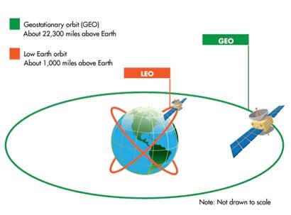
What is a geostationary satellite?
A geostationary satellite or geosynchronous orbit (GEO) is a satellite that is synched with the orbit of the Earth. Such satellites are placed at 35,786km above the Earth’s equator. At this height, a satellite is orbiting at exactly the same rate as the Earth is spinning (11,000km/hr!), so the ground is stationary below it. Consequently, the satellite is not moving relative to the Earth, hence the antenna does not need to move. This means that the satellites are facing and recording data from the same ‘patch’ of Earth constantly. Due to the distance of these satellites, geostationary satellites tend to be lower resolution than polar-orbiting satellites, however, the continuous coverage is advantageous.
Are there other types of satellites?
Yes! The other type of orbit is known as a Low Earth Orbit (LEO), since it is much closer to the Earth. Because the Earth moves below the satellite, it appears to move across the sky, taking about 10-15 minutes to cross from horizon to horizon. To gather data from these satellites, the dish must move to follow the path, so the ground stations that receive this data are known as ‘trackers.’
Satellite Ground Station Examples
ESS offer different varieties of satellite ground station systems that have been installed nationally and internationally:
Oberon
The Oberon system uses what is called a ‘tracking antenna’, as the name suggests, it tracks the satellites in space, on an XY mount, to collect data from a wide range of polar-orbiting environmental observation satellite systems, including those operated by NASA and NOAA. The Oberon has high precision X and L band reception and has been modified for European applications too to collect from more data sources (for more information see: http://www.eecradar.com/oberon-xl.php).
These systems are not only used for Meteorology and Weather Forecasting, there are also many applications in physical and biological oceanography, hydrology, fisheries, agriculture & forestry, climate, and global change studies, and land-based change detection studies.
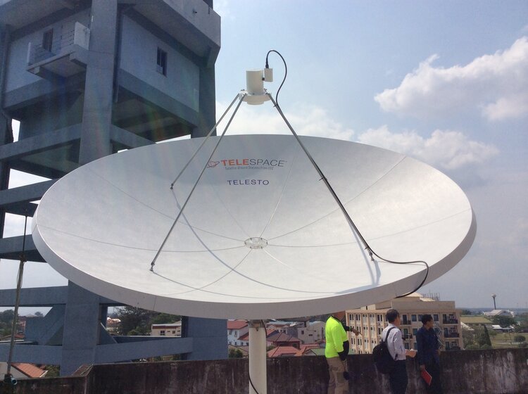
Capella and Telesto
The Capella and Telesto systems use a different kind of antenna, called a ‘fixed antenna.’ Once again in the name, suggests that these antennas do not move and are used to collect data from geostationary satellites including the Geostationary Operational Environmental Satellite-R Series (GOES-R). Capella comes with three different antenna sizes: 3.7m, 5m, and 6m, depending on the ground location from the satellite. They can be applied in the following areas: Storm detection and tracking, fire monitoring, air quality, coastal and ocean monitoring, hurricane forecasting, rainfall, and flood monitoring, land cover observations, volcanic ash detection, lightning detection, and severe thunderstorm prediction (for more information see: http://www.eecradar.com/capella-gr.php).
Telesto
Telesto is also a geostationary satellite ground station which is capable of picking up a different range of data sources and can be applied in weather forecasting, cyclone detection, and tracking, and volcanic ash detection and tracking (for more information see: http://www.eecradar.com/telesto.php)
Lastly, ESS offer a ground station specific to the Japanese Himawari-8 satellite. This includes reception of data that is higher in spatial resolution, more frequent data (every 10 minutes!), an increased amount of spectral bands improving the images produced and can provide visualisation of the following standard products: channels VIS, IR1-4, cloud-top pressure, cloud-top height, cloud-top temperature, cloud type, cloud amount, sea-surface temperature, land-surface temperature and fire points (for more information see: http://www.eecradar.com/himawari-8.php)
Data Types, Sources, and Software
There are many satellites orbiting Earth, so satellite ground stations can obtain data from a variety of different sources. Regarding the ground stations mentioned above, for tracking antennas sources can come from the following satellites:
-
NASA Terra and Aqua; National Aeronautics and Space Administration, United States
-
US NOAA; National Oceanic and Atmospheric Administration, United States
-
EUMETSAT – METOP; European Organisation for the Exploitation of Meteorological Satellites, Europe (Exact countries can be found here: https://www.eumetsat.int/website/home/AboutUs/WhoWeAre/MemberStates/index.html)
-
NSMC Fengyun; China Meteorological Administration National Satellite Meteorological Center, China
-
Suomi NPP; National Polar-orbiting Partnership, United States
-
JPSS-1; Joint Polar Satellite System, United States
And for stationary antennas:
-
GOES; Geostationary Operational Environmental Satellite, United States
-
MTSAT; Multifunctional Transport Satellites, Japan (Note: replaced Himawari-5)
-
FY-2; FengYun-2, China (Translation: FengYun —> Winds and clouds)
-
COMS; Communication, Ocean and Meteorological Satellites, South Korea
-
Himawari-8/9; Japan (Translation: Himawari —> Sunflower)
-
GK-2A; GEO-KOMPSAT-2, South Korea
Note: Typical types of data formats from satellites include – Level 1B, Level 2 products (e.g. sea surface temperature, cloud classification), HDF, NetCDF, GRIB, SYNOP
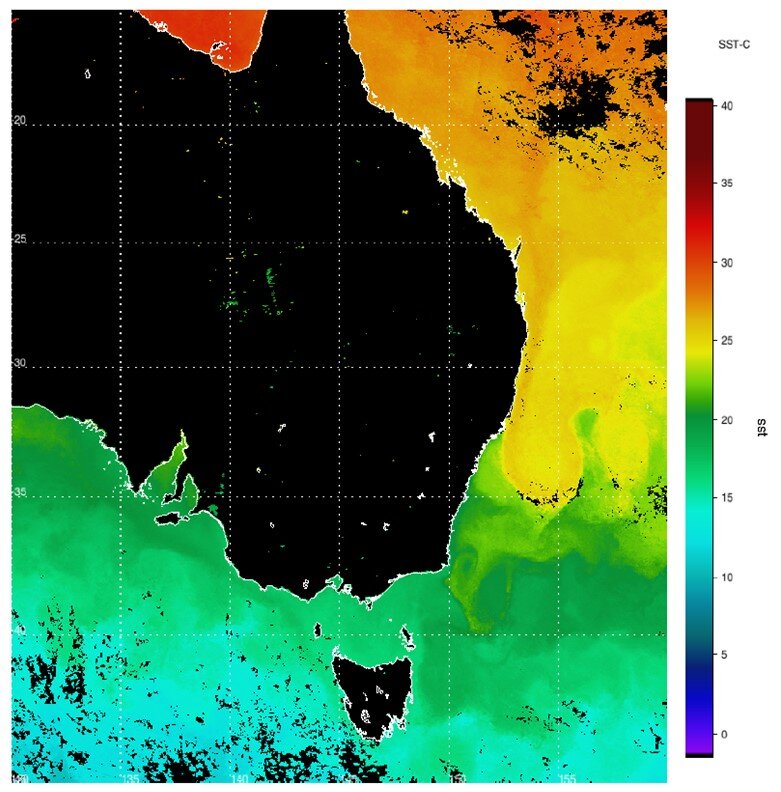
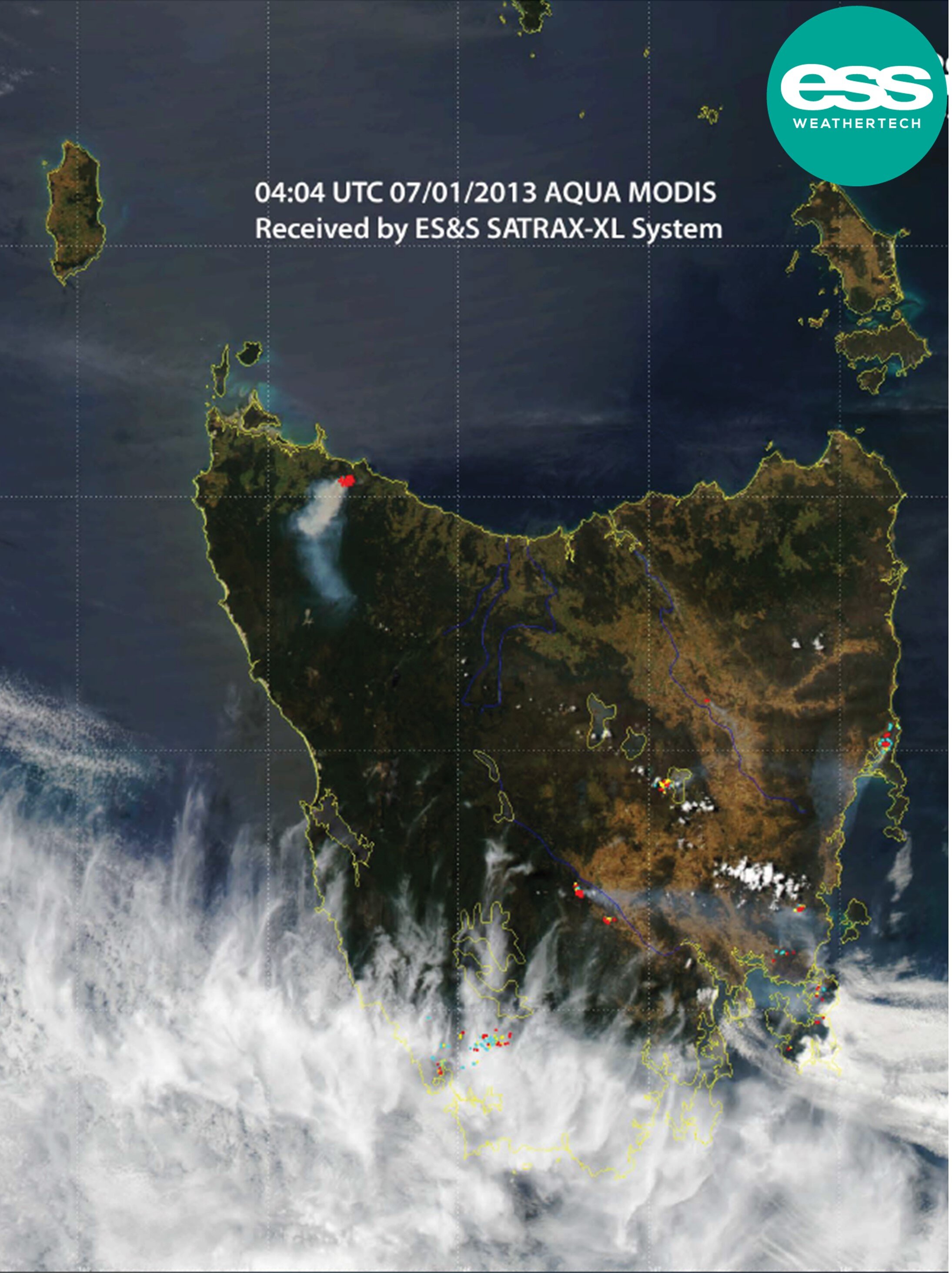
For the satellite data to then be visualised, specific workstations are set up to provide processing power and visualisation. This is so spectacular imagery of various parameters as per Figures 2 and 3 can be produced. ESS provide software known as PROTEUS (soon to be PULSE) and Himawari cast, specifically for the Himawari products.
Project History
ESS has been involved in many satellite ground station installs including continuous work on upgrading these systems over the years. ESS is also proud to house two satellite reception systems on our roof in Richmond, Melbourne (HimawariCast and SATRAX). Project installs include local projects within Australia, but also stretch internationally to several countries such as, Singapore, Hong Kong, China, South Korea, and even to the continent of Antarctica to name a few! See below a few handpicked projects from ESS’ impressive repertoire.
Geoscience Australia, Australia – Satellite Reception System
As COVID-19 restrictions begin to ease, our trusty local team in Melbourne are going to head to Alice Springs around December to install a fresh new satellite ground station system for reporting of Terra and Aqua, NOAA, MetOp A/B/C, SNPP, FY3-C/D and future NPAA21/22 and MetOp SG data! Watch this space. This will be the third ESS tracking antenna to be installed at the Geoscience Australia Alice Springs antenna farm in the past 25 years.
Hong Kong Observatory, Hong Kong –Oberon Satellite Reception System
In 2018, the Hong Kong Observatory commissioned a new satellite reception and data processing system from ESS to replace the originally supplied SATRAX antenna and radome installed back in 2003. The new and improved system now allows for the processing of new generation Chinese satellites (FY3B, C, and D) on top of the existing products from NOAA AVHRR, MetOpA/B, SNPP, NOAA20, Terra and Aqua.
National Environment Agency, Singapore – Himawari-8 Ground Station
ESS was pleased to enter a contract with the National Environment Agency (NEA) in 2015 for the design, supply, delivery, installation, testing, commissioning, and comprehensive maintenance of a Satellite Data Reception and Processing System for the reception and processing of data from the Japan Meteorological Agency (JMA) Himawari-8/9 satellites and an upgrade to the ESS SATRAX satellite tracking antenna for the Joint Polar Satellite System (JPSS). This includes a large 3.7m antenna dish that can receive a C-band feed of data. This project is still ongoing to support the maintenance of the system.